Home » Geology
Traps
NOMENCLATURE OF A TRAP
The highest point of the trap is the crest, or culmination.
The lowest point at which hydrocarbons may be contained in the trap is the spill point; this lies on a horizontal contour, the spill plane.
The vertical distance from crest to spill plane is the closure of the trap.
The zone immediately beneath the petroleum is referred to as the bottom water, and the zone of the reservoir laterally adjacent to the trap as the edge zone.
Within the trap the productive reservoir is termed the pay.
The vertical distance from the top of the reservoir to the petroleum/water contact is termed gross pay.
All of the gross pay does not necessarily consist of productive reservoir, so gross pay is usually differentiated from net pay.
The net pay is the cumulative vertical thickness of a reservoir from which petroleum may be produced. Development of a reservoir necessitates mapping the gross : net pay ratio across the field.
Within the geographic limits of an oil or gas field there may be one or more pools, each with its own fluid contact.
This field contains two pools, with different oil : water contacts (OWC). In the upper pool the net pay is much less than the gross pay because of non-productive shale layers. In the lower pool the net pay is equal to the gross pay.
DISTRIBUTION OF PETROLEUM WITHIN A TRAP
A trap may contain oil, gas, or both. The oil : water contact (OWC) is the deepest level of producible oil. Similarly, the gas : oil contact (GOC) or gas : water contact is the lower limit of producible gas.
Where oil and gas occur together in the same trap, the gas overlies the oil because the gas has a lower density.
Whether a trap contains oil and/or gas depends both on the chemistry and level of maturation of the source rock and on the pressure and temperature of the reservoir itself.
Fields with thick oil columns may show a more subtle gravity variation through the pay zone. Boundaries between oil, gas, and water may be sharp or transitional. Abrupt fluid contacts indicate a permeable reservoir; gradational ones indicate a low permeability with a high capillary pressure. Not only does a gross gravity separation of gas and oil occur within a reservoir, but more subtle chemical variations may also exist.
Fluid contacts in a trap are generally planar, but are by no means always horizontal. Correct identification of the cause of the tilt is necessary for the efficient production of the field. There are several causes of tilted fluid contacts.
They may occur where a hydrodynamic flow of the bottom waters leads to a displacement of the hydrocarbons from a crestal to a flank position. This displacement can happen with varying degrees of severity.
In some fields the OWC has tilted as a result of production, presumably because of fluid movement initiated by the production of oil from an adjacent field.
An alternative explanation for a sloping fluid contact is that a trap has been tilted after hydrocarbon invasion, and the contact has not moved.
A third possible cause of a tilted OWC may be a change in facies.
SEALS AND CAP ROCKS
For a trap to have integrity it must be overlain by an effective seal. Any rock may act as a seal as long as it is impermeable. Seals will commonly be porous, and may in fact be petroleum saturated, but they must not permit the vertical migration of petroleum from the trap. Shales are the commonest seals, but evaporites are the most effective. Shales are commonly porous, but because of their fine grain size have very high capillary forces that prevent fluid flow.
Shales may selectively trap oil, while permitting the upward migration of gas. Gas chimneys may sometimes be identified on seismic lines either by a velocity pull-down of the reflector on top of the reservoir, and/or by a loss in seismic character in the overlying reflectors. Indeed some petroleum accumulations are sometimes identified because of their gas-induced seismic anomalies.
CLASSIFICATION OF TRAPS
Physical Geology
Cyclothems- Cyclothems are alternating stratigraphic sequences of marine and non-marine sediments, sometimes interbedded with coal seams that are indicative of cyclic depositional regimes. The cyclothems consist of repeated sequences, each typically several meters thick, of sandstone resting upon an erosional surface, passing upwards to pelites (finer-grained than sandstone) and topped by coal.
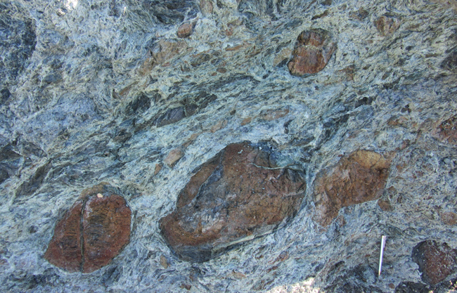
Mélange- A mélange is a large-scale breccia, a mappable body of rock characterized by a lack of continuous bedding and the inclusion of fragments of rock of all sizes, contained in a fine-grained deformed matrix(typically shale, slate, or serpentinite, with a tectonic fabric). The mélange typically consists of a jumble of large blocks of varied lithologies. Both tectonic and sedimentary processes can form mélange.
Mélange occurrences are associated with thrust faulted terranes in orogenic belts. A mélange is formed in the accretionary wedge above a subduction zone. The ultramafic ophiolite sequences which have been obducted onto continental crust are typically underlain by a mélange. Smaller-scale localized mélanges may also occur in shear or fault zones, where coherent rock has been disrupted and mixed by shearing forces.
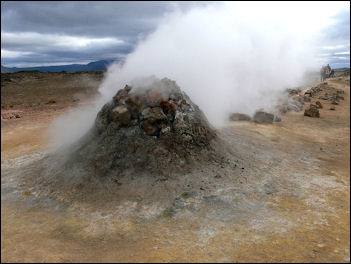
Fumarole, vent in the Earth’s surface from which steam and volcanic gases are emitted. The major source of the water vapour emitted by fumaroles is groundwater heated by bodies of magma lying relatively close to the surface. Carbon dioxide, sulfur dioxide, and hydrogen sulfide are usually emitted directly from the magma. Fumaroles are often present on active volcanoes during periods of relative quiet between eruptions.
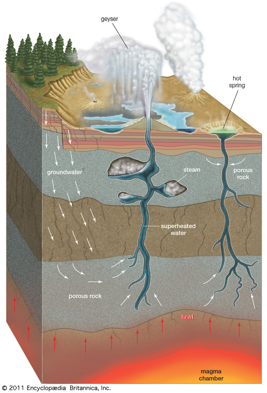
Fumaroles are closely related to hot springs and geysers. In areas where the water table rises near the surface, fumaroles can become hot springs. A fumarole rich in sulfur gases is called a solfatara; a fumarole rich in carbon dioxide is called a mofette.
Geyser, hot spring that intermittently spouts jets of steam and hot water. Geysers result from the heating of groundwater by shallow bodies of magma. They are generally associated with areas that have seen past volcanic activity. The spouting action is caused by the sudden release of pressure that has been confining near-boiling water in deep, narrow conduits beneath a geyser. As steam or gas bubbles begin to form in the conduit, hot water spills from the vent of the geyser, and the pressure is lowered on the water column below. Water at depth then exceeds its boiling point and flashes into steam, forcing more water from the conduit and lowering the pressure further. This chain reaction continues until the geyser exhausts its supply of boiling water.
As water is ejected from geysers and is cooled, dissolved silica is precipitated in mounds on the surface. This material is known as sinter.
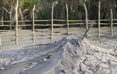
Mud volcano, mound of mud heaved up through overlying sediments. The craters are usually shallow and may intermittently erupt mud. These eruptions continuously rebuild the cones, which are eroded relatively easily.
Some mud volcanoes are created by hot-spring activity where large amounts of gas and small amounts of water react chemically with the surrounding rocks and form a boiling mud.
Variations are the porridge pot (a basin of boiling mud that erodes chunks of the surrounding rock) and the paint pot (a basin of boiling mud that is tinted yellow, green, or blue by minerals from the surrounding rocks). Other mud volcanoes, entirely of a nonigneous origin, occur only in oil-field regions that are relatively young and have soft, unconsolidated formations. Under compactional stress, methane and related hydrocarbon gases mixed with mud force their way upward and burst through to the surface, spewing mud into a conelike shape. Because of the compactional stress and the depth from which the mixture comes, the mud is often hot and may have an accompanying steam cloud.
Hot spring, also called thermal spring, spring with water at temperatures substantially higher than the air temperature of the surrounding region. Most hot springs discharge groundwater that is heated by shallow intrusions of magma (molten rock) in volcanic areas. Some thermal springs, however, are not related to volcanic activity. In such cases, the water is heated by convective circulation: groundwater percolating downward reaches depths of a kilometre or more where the temperature of rocks is high because of the normal temperature gradient of the Earth’s crust—about 30 °C (54 °F) per kilometre in the first 10 km (6 miles).


